ROAD SIGNS OF ILLINOIS
All photos taken by Mark O'Neil unless otherwise noted
Updated March 2, 2002
INTERSTATE SIGNS
 |
(February 2000) Current style Illinois interstate sign without the
state name. Illinois dropped the state name from its interstate signs in the mid-1980's. |
 |
Older interstate highway sign with "ILLINOIS" and small number fonts. (My collection) |
US HIGHWAY SIGNS
 |
(July 1999) Vandalia, IL. Lot of signs in this photo. These are current US Highway shields with
large numbers centered within the shield. Older signs have smaller numbers placed near the
bottom of the shield (I'll have to see if I can find one of those around somewhere). Also
included are the current three-digit state shield and a marker for the Lincoln Heritage Trail
which traverses southern Illinois. |
 |
Older cutout US highway shield. This sign is probably from the late
50's or early 60's due to the fact that it has a scotchlite reflective background. These signs
were phased out starting in 1965. (My collection) |
 |
Another cutout US highway shield. This sign was an
interim between the embossed and silkscreened series. The legends and border are embossed with
a silkscreened number. This crushed-glass reflective sign is dated 1937 on back, suggesting that
the embossed sign is a leftover blank, but the number probably wasn't applied until
the 1940's. The "6" is in the FHWA-font, which didn't come into use until the late-1940's. The
sign was probably used into the 1950's. (Collection of Robert Edgar) |
STATE HIGHWAY SIGNS
 |
Current style state route marker. Note that the "0" is actually a sticker
covering up a "3". Signs since the late 70's have had a small "ILLINOIS" above the number
(My collection). |
 |
(November 2000) Lincolnwood, IL. Illinois started to phase in this design
around 1965. This is the original design with the large "ILLINOIS" above the route number. |
 |
(December 2000) East Moline, IL. Illinois state route markers on big green
signs omit the black line border. |
 |
(October 2001) Paxton, IL. Unusual Illinois state route marker that
omits the state name. |
 |
Older style Illinois marker. This sign probably dates to the late 50's
or early 60's as it is aluminum and has a Scotchlite reflective background. Earlier three-digit signs do not cut the
state shape for the number. (My collection) |
COUNTY ROUTE SIGNS
 |
(January 2000) Roselle, IL. About half of the counties in Illinois use
county route markers. Illinois uses the standard pentagon shaped sign. This is the newer-style
sign with the county name and border in the same gold color as the numbers. |
 |
(January 2000) Roselle, IL. This photo was taken on the other side of
the road from the photo above. This is the older style sign with the county name and border in
light yellow (which has almost faded to white). Note the different spellings of the name "DuPage" |
OTHER ROUTE MARKERS
THE ILLINOIS TOLLWAY SYSTEM
A constant source of controversy among Chicagoans are the tollways.
Construction of the tollway system started before the Interstate Highway Act was signed into
law in 1956. In order to fund these new superhighways around Chicago, the state created the
Illinois Toll Highway Authority and gave the organization authority to issue bonds backed by tolls
collected on its highways. The Tri-State Tollway was completed in 1958 closely followed by the
Northwest Tollway.
In the early 1980's the bonds on the oldest tollways were paid off. In a controversal move, the
ITHA converted funds collected from the Northwest and Tri-State tollways to pay off the bonds on
the newer tollways including the East-West extension and later the North-South tollway.
Unlike other states with multiple tollways, the ITHA developed one sign used to identify any
tollway within the system. These signs are not used as reassurance signs, but rather as trailblazers
directing motorists to the nearest tollway.
The signs simply bear the logo of the ITHA with an arrow pointing to the closest tollway. The
ITHA changed its logo in the late 1980's, thus the signs changed also.
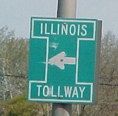
 |
(March 2000) Forest Park, IL. These signs bear the original logo of the ITHA
and should have been removed in the late 1980's. Fortunately, some remain in Chicago and some
of its older suburbs. Older signs have movable arrows. |
|
 |
THE ELGIN-O'HARE EXPRESSWAY
In the early 1990's, IDOT built the Elgin-O'Hare
Expressway. It's a very odd expressway in northwest suburban Chicago in that it is not numbered
and it doesn't go to either Elgin or O'Hare Airport. For this reason, it's been nicknamed the
"Elgin-Nowhere". IDOT is apparently unsure how to sign this road - each exit has it own style of
signage. There are no reassurance markers on the road aside from what's on the overhead signs.
 |
(January 2000) Schaumburg, IL. This sign suggests that someday the Elgin-O'Hare
will be numbered. Perhaps it will pick up the IL 19 designation as that road runs somewhat parallel
to the expressway. The Elgin-O'Hare does not link up to any other interstate (it turns into Thorndale
Ave. about 1/2 mile from the I-290 interchange) |
 |
(January 2000) Schaumburg, IL. These signs are somewhat similar to Illinois
state route markers and are only found at the Irving Park Rd (IL 19) and Springinsguth Rd interchanges. |
Go to:
THE SIGN PAGE
THE ROAD PAGE
HOME PAGE
All images Copyright 1998 - 2002 by Mark O'Neil or by their respective owners